Virtual Tour
The map below features links to images and information about streets, houses, tenements, apartment buildings, theaters and churches in the South Village. The links include buildings that are as much as 200 years old and embody some of the richest history in the Village and in New York. They tell the story of the founding of Greenwich Village as a refuge from the yellow fever epidemics of New York City (then the southern tip of Manhattan) in the early 19th century, of the South Village's role as a center of immigrant life in the late 19th century, as a center for artists, bohemians, and "free-thinkers" in the early 20th century, of beatniks, hippies, folk musicians, and the counterculture in the second half of the 20th century, and today, as an eclectic mix of old and new, avant-garde and traditional, gritty and glamorous, sacred and profane.
Unfortunately, the South Village is not in a New York City historic district, and therefore is not protected from inappropriate demolitions, alterations, or new construction. The Greenwich Village Society for Historic Preservation is seeking to change this, and is working to protect this area through research, documentation, advocacy, and education, which we hope will lead to recognition of its unique and valuable historic and architectural features, and the enactment of historic district protections. Read more.
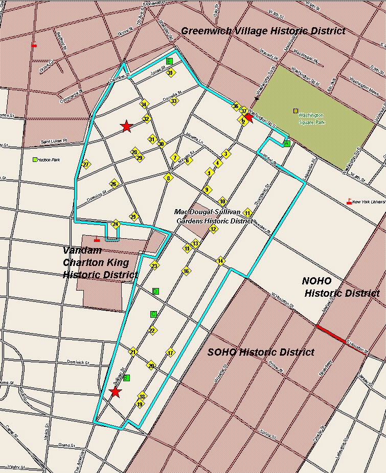
Click on the links on the map below for more information and pictures of each site.
Map generously provided by Edward
Camp of Geographic Business Systems of Paramus 201-587-1717,
www.geobussys.com.
Map Sites Listed by Name
1. & 2. 127-131 MacDougal Street, houses at 125-131 MacDougal Street and the Provincetown Playhouse
3. Rowhouses at 130, 132 MacDougal Street
4. MacDougal Street between West 3rd and Bleecker Streets
5. Tenements on MacDougal Street
7. Our Lady of Pompeii Church overlooking Father Demo Square
8. Sixth Avenue
9. Beaux-Arts Tenement at Bleecker and MacDougal Streets, 185 Bleecker Street
10. 173-177 Bleecker Street/206 Sullivan Street
11. Bleecker Street from LaGuardia Place to 6th Avenue
12. Sullivan Street, including Sullivan Street Playhouse
14. Houston Street
15. St. Anthony of Padua Church
16. View down Sullivan Street below Houston Street, south from St. Anthony of Padua Church
17. Streetscape details, Thompson Street
18. Thompson streetscape with new tower rising above
19. Cast iron detail, typical South Village storefront, 68-74 Thompson Street
20. Altered rowhouses on Spring Street
22. Sullivan Street north from Vesuvio Playground
23. Romanesque tenement on MacDougal Street
24. Rowhouses on West Houston Street
25. Curving streetscape, Bedford Street
26. Downing Street "cul-de-sac"
28. Carmine Street, looking north to Our Lady of Pompeii Church
29. South Side of Carmine Street
30. 233 and 237 Bleecker Street
31. Our Lady of Pompeii Church
32. Layers of History on Leroy Street
33. Cornelia Street, one block long
34. Federal rowhouses and their neighbors on Bleecker Street
35. Jones Street
36. Intricately detailed entrance, 140 West 4th Street
37. 132 and 134 West 4th Street, classic Greek Revival rowhouses
Individually Designated Landmarks
A. Judson Memorial Church, Tower, and Hall
B. 83 and 85 Sullivan Street Houses
E. 26, 28, and 30 Jones Street Houses
Federal Rowhouses Proposed for Individual Landmark Designation
127, 129 and 131 MacDougal Street
Designated Historic Districts
MacDougal Sullivan Gardens Historic District
Charlton - King - Vandam Historic District
Historic Maps
Anthony Lispenard and Others, May 1882
Map of the Estates of Sir Peter Warren
Samuel Boyd, George Rapelje & John Staples, April 1881
Map of the Haring or Herring Farm as Surveyed in 1784, January 1869
If you want to support GVSHP and its efforts to preserve the South Village, CLICK HERE.
If you want to be kept informed of the South Village preservation campaign, email:
SouthVillage@gvshp.org. Be sure to include your name, address and phone number.
Did you or your family live, work, or have a business in the South Village? If you have stories, pictures, or information about the history of the South Village, please share it with us. CLICK HERE for email, or you can write to us at GVSHP, 232 E. 11th Street, New York, NY 10003, or call 212-475-9585.